Recent reports (34)
Comprehensive evergreen guide to Catskill Park hiking covering trail conditions, seasonal weather, camping rules, and hiking challenges. Highlights that trails are steeper and rockier than their elevations suggest, with winter ice on ledges requiring microspikes or crampons; spring and fall bring variable conditions at higher elevations.
adk-balsam-lake,
adk-hunter,
cat-balsam-cap,
cat-blackhead,
cat-cornell,
cat-friday,
cat-indian-head,
cat-kaaterskill-high,
cat-lone,
cat-panther,
cat-peekamoose,
cat-plateau,
cat-rocky,
cat-slide,
cat-sugarloaf,
cat-table,
cat-twin,
cat-west-kill,
cat-windham-high,
cat-wittenberg
coldcrampons-requirederodedexposedicemudrockyscrambleslippery-rootssnowsnowshoes-requiredspikes-requiredsteepthunderstorm-risktrail-degradedwetwet-rock
Hikers encountered access restrictions at Sugarloaf ski resort despite having purchased an access pass, with ski patrol initially denying summit access due to liability concerns. After negotiation, they completed a ridge traverse to Spaulding with significant wind-drifted snow, steep descent sections on wet sticky snow, and navigation challenges due to obliterated trail markings.
blowdown-navigationdeep-snowslushsnowsteepwet
A comprehensive peakbagging guide for the Catskill 3500 Club, describing routes, difficulty levels, and strategic pairing of 33 publicly-accessible Catskill peaks above 3,500 ft. The guide covers single peaks, pairs, triplets, and multi-peak challenge routes with no specific trail conditions reported.
adk-balsam-lake,
adk-hunter,
cat-balsam,
cat-balsam-cap,
cat-bearpen,
cat-big-indian,
cat-black-dome,
cat-blackhead,
cat-cornell,
cat-eagle,
cat-fir,
cat-friday,
cat-halcott,
cat-indian-head,
cat-kaaterskill-high,
cat-lone,
cat-north-dome,
cat-panther,
cat-peekamoose,
cat-plateau,
cat-rocky,
cat-rusk,
cat-sherrill,
cat-slide,
cat-sugarloaf,
cat-table,
cat-thomas-cole,
cat-twin,
cat-vly,
cat-west-kill,
cat-windham-high,
cat-wittenberg
Platte Clove Road, a key access route to Eastern Devil's Path and Catskill trailheads including Kaaterskill High Peak, Twin, Sugarloaf, and Indian Head, is closed annually from November through late April or May for winter and road repairs. The page provides current status updates and alternate routing information for accessing these popular hiking areas when the road is closed.
Multi-year collection of user-submitted Catskill trail conditions reports covering seasonal variations in snow, ice, mud, and water conditions across numerous peaks and routes. Reports span from 2021–2025 and include details on required gear (spikes, snowshoes, crampons) and trail hazards for planning purposes.
adk-balsam-lake,
adk-hunter,
cat-balsam,
cat-balsam-cap,
cat-black-dome,
cat-blackhead,
cat-cornell,
cat-eagle,
cat-friday,
cat-giant-ledge,
cat-halcott,
cat-indian-head,
cat-kaaterskill-high,
cat-north-dome,
cat-panther,
cat-peekamoose,
cat-plateau,
cat-rusk,
cat-sherrill,
cat-slide,
cat-sugarloaf,
cat-thomas-cole,
cat-twin,
cat-west-kill,
cat-windham-high,
cat-wittenberg
blowdownbreakable-crustbug-heavycoldcornice-riskcrampons-requireddeep-snowdryerodedfrozen-groundhard-icehigh-waterhigh-windiceloose-rocklow-visibilitymudmud-deeppostholingrainrime-icerotten-snowscramblescreeslabslide-routeslushsnowsnowshoes-requiredspikes-requiredstream-crossing-difficultthunderstorm-riskverglaswater-availablewater-drywater-scarcewater-stagnantwetwet-rock
This is a curated collection of user-submitted trail condition reports for Catskill peaks spanning from late 2021 through April 2025, covering seasonal conditions including snow, ice, mud, trail quality, water availability, and wildlife/bug activity across multiple routes and elevations.
adk-hunter,
cat-balsam,
cat-balsam-cap,
cat-bearpen,
cat-big-indian,
cat-black-dome,
cat-blackhead,
cat-cornell,
cat-eagle,
cat-fir,
cat-friday,
cat-halcott,
cat-indian-head,
cat-kaaterskill-high,
cat-lone,
cat-north-dome,
cat-panther,
cat-peekamoose,
cat-plateau,
cat-rocky,
cat-rusk,
cat-sherrill,
cat-slide,
cat-sugarloaf,
cat-thomas-cole,
cat-twin,
cat-vly,
cat-west-kill,
cat-windham-high,
cat-wittenberg
blowdownbreakable-crustbug-heavycoldcrampons-requireddeep-snowdryerodedexposedfrozen-groundhard-icehigh-windicelow-visibilitymudmud-deepovergrownparking-fullpostholingrainrime-icerotten-snowslushsnowsnowshoes-requiredspikes-requiredsteepverglaswater-availablewater-drywater-scarcewetwet-rockwhiteout
An experienced 65-year-old hiker from Connecticut sustained an ankle injury on the icy west side of Sugarloaf Mountain in winter conditions. A multi-ranger rescue operation involving technical rope rigging and a rescue sled took approximately eight hours to extract the hiker from difficult terrain and transport to the hospital.
exposedhard-iceicesteep
A classic out-and-back route via Platte Clove crossing Kaaterskill High Peak summit and descending to Hurricane Ledge. The trail typically features significant mud, inconsistent blazing, and complex route-finding with multiple intersecting old roads and trails.
bushwhackmud
The Eastern Devil's Path is a challenging 12-mile Catskill thru-hike traversing four peaks with nearly 5,000 feet of elevation gain and loss; features rugged terrain, steep notches, rock scrambles, and relentless ups and downs requiring 8–12 hours to complete with limited water sources.
exposedrockyscramblesteep
General overview of mud season conditions and trail maintenance best practices on Catskill peaks, noting that Kaaterskill High, West Kill, Hunter, Sugarloaf, and Windham High are particularly prone to muddy and waterlogged sections.
mudwet
A winter traverse of Sugarloaf, Spaulding, and Abraham in Maine on March 7, 2023, with unbroken trail most of the ridge and significant trail-breaking required above treeline. Recent snowfall (nearly 3 feet in 7 days) left the route largely untracked except for scattered evidence of prior hikers, though some broken trail appeared on the Fire Warden's descent. The 16-mile traverse took 12 hours with cloud coverage and wind on the exposed ridge.
bushwhackdeep-snowexposedhigh-windlow-visibilitypostholingsnow
An evergreen trail guide to the Devil's Path, a 24-mile point-to-point hiking route through the Catskills known for extreme difficulty, relentless elevation gain/loss, and significant winter mountaineering hazards on iced western flanks. The guide covers seasonal closures, water scarcity, trailhead information, and route details for the eastern and western halves.</summary>
<parameter name="confidence">Low
exposedhard-iceicemudrockyscramblesnowshoes-requiredspikes-requiredsteeptrail-closedwater-drywater-scarcewet-rock
On February 11, 2023, the author hiked a 9.2-mile loop from Roaring Kill to Plateau and Sugarloaf. The route featured packed snow and significant hard ice sections, particularly on the steep western side of Sugarloaf, requiring microspikes or crampons for safe passage. Conditions were challenging but manageable with proper equipment and good snow traction.
crampons-requiredhard-icesnowsnowshoes-requiredspikes-requiredsteepwater-available
This guide describes a short, moderate out-and-back route to Dibbles Quarry between Twin and Sugarloaf mountains, featuring an abandoned 1800s bluestone quarry, stream crossings, hemlock groves, and a beaver pond. The main quarry is less than a mile from the trailhead and can be muddy; beyond it lie scenic views, a waterfall, and further exploration areas.
mudstream-crossing-difficultwater-available
Winter hiking guide for the safest route to Sugarloaf Mountain via Dibbles Quarry and Pecoy Notch from Roaring Kill trailhead. Microspikes required minimally; snowshoes recommended in deeper snow. Author attempted the route in February 2022 and had to turn back at 3200' due to deteriorating weather before returning two weeks later on better conditions.
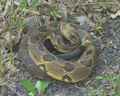
bear-activitycoldexposedicescramblesnowsnowshoes-requiredspikes-required
A hiker climbed Sugarloaf with their dog Starlight. No specific trail conditions were reported.
Trail guide for Plateau Mountain via Mink Hollow North, describing a 1.5-mile steep route to the summit and optional extension to Daley Ridge Lookout. The route features rock scrambles, dramatic outcroppings, and a scenic ridge walk through mixed birch and spruce forest.
exposedrockyscramblesteep
Route guide for Plateau Mountain via Stony Clove Notch, featuring a steep 1-mile initial climb to Orchard Point lookouts followed by an easy 2.25-mile ridge walk to the summit. Author describes April conditions with residual monorail and mentions seasonal considerations including microspikes on the ridge and exposed sun exposure in summer months.
high-windhotmonorailscramblespikes-requiredsteep
This is a challenging 6.5-mile bushwhack thru-hike over North Dome and Mount Sherrill that requires advanced navigation skills and solid off-trail experience. The route features steep ledges on North Dome's eastern side, dense evergreen forest, and (as of an April visit) significant ice, snow, and icicle formations requiring microspikes.
bushwhackexposediceovergrownscramblesnowspikes-requiredsteep
This is an evergreen trail guide to Twin Mountain via Jimmy Dolan Notch describing the route, terrain, and seasonal conditions. The guide notes that winter travel requires microspikes at minimum due to ice-flows and ice-covered boulders on steep sections, and mentions a challenging rock scramble with verglas conditions.
exposedicerockyscramblespikes-requiredsteepverglas
Huckleberry Point is a popular Catskills ledge hike with a tricky stream crossing after rain; the trail is characteristically wet and muddy year-round with beautiful escarpment views. The route is short and easy, taking about 75 minutes to reach the dramatic vista, and features variable terrain with rock ledges and hemlock-laurel forest.
exposedmudrockystream-crossing-difficultwet
Detailed trail guide for the counterclockwise loop route on Sugarloaf via Mink Hollow and the western "Suicide Side," featuring steep rocky and muddy sections with rugged scrambling, boulders, and rock chasms. The route is not recommended in winter due to avalanche and technical climbing hazards on the western flank; summer/warmer months offer the best hiking with scenic views and moderate bug activity typical of late summer.
bug-heavyexposedloose-rockmudmud-deeprockyscramblesteep
Detailed evergreen route guide for Twin Mountain via the Roaring Kill trailhead, describing an out-and-back hike featuring the scenic Dibbles Quarry and Beaver Pond approach, followed by a technically challenging and exposed ascent on the west side from Pecoy Notch to the summit. The upper section contains dangerous boulder scrambles with significant fall risk and ankle-twisting hazards, though a 2019 reroute mitigates some of the original danger.
exposedloose-rockmudrockyscramblesteepstream-crossing-difficult
A detailed evergreen trail guide for the Balsam Mountain loop from Rider Hollow, including route description, landmarks, and typical conditions. Includes comments from user visits noting fresh snow with deep postholes requiring snowshoes, and stinging nettles in summer.
deep-snowovergrownpostholingsnowshoes-requiredstream-crossing-difficultwater-available
This is an evergreen trail guide describing the Dutcher Notch Trail approach to Arizona Mountain from Stork's Nest Road, featuring steep terrain, dramatic boulder formations, and scenic views of the Devil's Path peaks. Comments from hikers include reports of bone-dry conditions in October 2021, ankle-deep wet leaf cover on steep sections in October 2020, and variable weather with clearing skies.
drylow-visibilitymudovergrownrainrockyscrambleslippery-rootssteepwet
Route description of West Kill via St. Anne's Peak, including terrain, trail conditions, and seasonal observations. The hike features steep sections, rocky terrain on the east side of St. Anne's, and boreal woods on West Kill's west side; a road walk back to trailhead can be used as alternate descent.
bear-activitybushwhacklow-visibilityrockyscramblesteep
Evergreen trail guide describing a route up Sugarloaf and Twin Mountains from the Roaring Kill trailhead in the Catskills, highlighting steep terrain, rock scrambles, boulders, and ledge views. The western side of Twin features a challenging talus field and exposed rock face.
exposedloose-rockrockyscramblesteep
A moderate, multi-peak route crossing four summits with scenic vistas; features one tricky rock ledge around 2800' and a rock chute below 3750' that can be iced and hazardous in winter. Excellent views from a ledge near Black Dome's summit overlooking the Catskills region.</summary>
<parameter name="confidence">Medium
exposedicerockyscramble
This is a detailed trail guide for ascending Plateau Mountain via Mink Hollow, describing it as one of the steepest routes in the Catskill Park with 1600 feet of elevation gain over 1.5 miles. The route features multiple rock scrambles and ledge systems, wet terrain on the eastern side, and dense blowdown on the plateau. The guide includes seasonal observations and mentions winter conditions with snow cover.
blowdownexposedrockyscramblesteepwater-availablewetwet-rock
A detailed evergreen trail guide for a loop combining Indian Head and Twin mountains via the Devil's Path and Jimmy Dolan Notch. The route features classic Catskill forest, rock scrambles, scenic views, and a treed-in summit on Indian Head with excellent vistas from Twin's lower ledge.
exposedrockyscramblesteep
Evergreen trail guide describing the Kaaterskill High Peak route from Platte Clove with a long muddy approach, multiple junctions, and historic plane wrecks en route. Trail conditions include deep mud in lower sections, lively streams, and variable ice conditions in late November.
bogcrampons-requiredexposedicemudmud-deepovergrownspikes-requiredsteepwater-availablewet
A detailed guide to hiking Hunter Mountain and Southwest Hunter (Leavitt Peak) from Stony Clove Notch, covering the steep eastern approach via Devil's Path, the herd path to Southwest Hunter, and the longer yellow-blazed route to Hunter's summit and fire tower. The eastern side is described as steep, wet, muddy, and rocky with significant rock outcroppings, while Becker Hollow descent is relentlessly steep with grades averaging 18.5% and reaching 23% near the summit.</summary>
<parameter name="confidence">Medium
loose-rockmudrockyscrambleslippery-rootssteepwetwet-rock
Detailed route guide for the Sugarloaf clockwise loop via Dibbles Quarry and Mink Hollow. The west side descent features loose, shattered boulders and is exceptionally wet with slippery rocks; the author notes that in winter this side becomes icy ("Suicide Mountain") and requires crampons. Spring conditions include boggy ridges with mud patches on the east side approach.
bogbushwhackloose-rockmudovergrownscrambleslippery-rootstrail-degradedwet-rock
A route guide describing the Blackhead and Black Dome loop via Lockwood Gap, with detailed descriptions of hiking conditions, notable winter hazards including blue ice blocks and slippery sections requiring microspikes, and scenic viewpoints along the route.
adk-hunter,
cat-black-dome,
cat-blackhead,
cat-indian-head,
cat-kaaterskill-high,
cat-north-dome,
cat-plateau,
cat-sherrill,
cat-sugarloaf,
cat-thomas-cole,
cat-twin,
cat-windham-high
exposedicerockyscramblesnowshoes-requiredspikes-requiredsteepwater-available